


Handy GPS lite

توضیحات Handy GPS lite
همراه عالی برای ماجراجویی در فضای باز بعدی شما. جستجو، پیدا کردن، ضبط و بازگشت به خانه با GPS دستی. بدون نیاز به حساب کاربری یا تنظیم - فقط آن را نصب کنید، GPS خود را روشن کنید و بروید!
این برنامه یک ابزار ناوبری قدرتمند است که برای ورزش های خارج از منزل مانند پیاده روی، پیاده روی در بوته، پیاده روی، دوچرخه سواری در کوهستان، کایاک سواری، سواری در مسیر اسب سواری و geocaching طراحی شده است. همچنین برای نقشه برداری، معدن، باستان شناسی، و برنامه های جنگلداری مفید است. استفاده از آن ساده است و حتی در دورافتاده ترین کشور عقب هم کار می کند زیرا به اتصال شبکه نیاز ندارد. این به شما امکان می دهد در مختصات UTM یا lat/lon کار کنید تا حتی بتوانید از آن با نقشه های توپوگرافی کاغذی خود استفاده کنید.
توجه: این یک نسخه آزمایشی رایگان است و فقط به ذخیره 3 نقطه بین راه و 40 نقطه ثبت مسیر محدود می شود. شما می توانید تا زمانی که می خواهید از نسخه آزمایشی استفاده کنید، اما اگر این برنامه را دوست دارید، لطفاً نسخه پولی "Handy GPS" را نصب کنید تا نسخه نامحدودی با ویژگی های بسیار بیشتر دریافت کنید. با تشکر!
همچنین، به برنامه اجازه دهید همیشه از GPS استفاده کند و بهینهسازی باتری را خاموش کنید تا برنامه بهطور قابلاطمینانی رد لاگها را زمانی که صفحه گوشی خاموش است ضبط کند.
ویژگی های پایه:
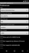
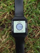
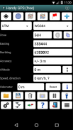
* مختصات فعلی، ارتفاع، سرعت، جهت سفر و کل مسافت طی شده شما را در واحدهای متریک، امپراتوری/آمریکا یا دریایی نشان می دهد.
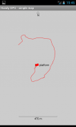
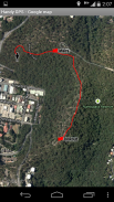
* می تواند مکان فعلی شما را به عنوان یک ایستگاه بین راهی ذخیره کند و یک گزارش مسیر برای نشان دادن جایی که روی نقشه بوده اید را ثبت کند.
* داده ها را می توان از فایل های KML و GPX وارد و صادر کرد.
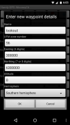
* ورود دستی نقاط بین راه را در UTM، MGRS و lat/lon coords اجازه می دهد.
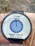
* می تواند با استفاده از صفحه نمایش "برو" شما را به یک نقطه بین راه راهنمایی کند و به صورت اختیاری هنگام نزدیک شدن شما یک هشدار به صدا درآورد.
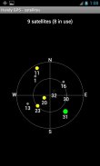
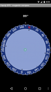
* دارای صفحه قطب نما است که روی دستگاه های دارای حسگر میدان مغناطیسی کار می کند.
* به طور خودکار افست ژئویدی محلی را برای بهبود دقت ارتفاع محاسبه می کند
* از داده جهانی WGS84 همراه با داده های رایج استرالیایی و شبکه های نقشه پشتیبانی می کند. می توانید از WGS84 برای نقشه های NAD83 در ایالات متحده استفاده کنید.
* مکان های ماهواره GPS و قدرت سیگنال را به صورت گرافیکی نشان می دهد.
* می تواند منابع شبکه ساده یا MGRS را نمایش دهد.
* می تواند فاصله و جهت نقطه بین راه را محاسبه کند.
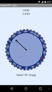
* شامل یک خط تایمر اختیاری برای ثبت مدت پیاده روی و محاسبه میانگین سرعت شما.
* به طور کامل توسط توسعه دهنده در بسیاری از پیاده روی های خارج از مسیر آزمایش شده است
ویژگی های اضافی فقط در نسخه پولی:
* بدون تبلیغات
* تعداد نامحدودی از ایستگاه های بین راه و نقاط ورود به سیستم.
* نقشه های آفلاین
* داده های سفارشی
* مشخصات ارتفاعی.
* عکس بگیرید و یادداشت های صوتی را از برنامه ضبط کنید.
* موقعیت مکانی خود را به یک دوست ایمیل یا پیامک کنید.
* ارجاعات شبکه بریتانیا.
* میانگین گیری GPS برای بهبود دقت مکان،
* زمان طلوع و غروب خورشید.
* نقاط بین راه و tracklog را به یک فایل CSV صادر کنید.
* نقاط بین راه را با استفاده از بلبرینگ و فاصله پروژه کنید.
* طول، مساحت و تغییر ارتفاع را از tracklog محاسبه کنید.
* محاسبه کالری
مجوزها: (1) GPS - برای تعیین موقعیت مکانی شما، (2) دسترسی به شبکه - برای دسترسی به لایههای نقشه استاندارد و کاشیهای OSM، (3) دسترسی به کارت SD - برای بارگیری و ذخیره ایستگاههای بین راه و لاگها، (4) دسترسی به دوربین برای گرفتن عکس عکس*، (5) جلوگیری از خوابیدن تلفن به طوری که زنگ مجاورت کار کند، (6) چراغ قوه را کنترل کنید تا چراغ قوه از داخل برنامه روشن/خاموش شود، (7) ضبط صدا برای یادداشت های صوتی*. (* ویژگی فقط در نسخه کامل برنامه موجود است).
سلب مسئولیت: شما از این برنامه با مسئولیت خود استفاده می کنید. توسعه دهنده هیچ مسئولیتی در قبال گم شدن یا زخمی شدن شما در نتیجه استفاده از این برنامه نمی پذیرد. باتری های دستگاه های تلفن همراه ممکن است خالی شوند. برای پیاده روی های طولانی و از راه دور، یک بانک باتری و یک روش ناوبری جایگزین مانند نقشه کاغذی و قطب نما برای ایمنی توصیه می شود.
Handy GPS lite - نسخه 42.8
(21-11-2024)
Handy GPS lite - اطلاعات APK
نسخه APK: 42.8حزمة: binaryearth.handygpsfreeآخرین نسخه Handy GPS lite
سایر نسخهها


اپلیکیشنها در دسته مشابه

شاید دوست داشته باشید...


